General
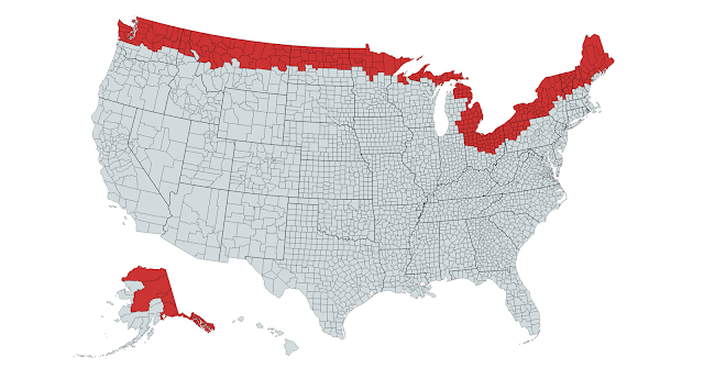
In order to determine which people lived within 100 miles from the border, 2nd level administrative districts were used and if they overlapped a circle which had a radius of 100 miles or less and was centered on the border, then it's entire population was deemed 100 miles from the border. In the USA, 2nd level administrative districts are called counties. In Canada, they are refereed to as census districts.
Spreadsheet with numbers per 2nd level admin. district found here.
Tools Used:
Countries
The United States of America
Map of Counties Selected
 | |
|
Findings:
Based of 2013 data provided by Wikipedia and Google
Of the approximately 316.5 million people in the USA, 28.87 million live in counties 100 miles from the Canadian border. 9.12% of the US population lives in counties 100 miles or less from the Canadian border.
Canada
Map of Census Districts Selected
 |
| Created Using mapchart.net |
Findings
Based of 2011 data provided by Wikipedia
Of the approximately 33.48 million people in Canada, 27.87 million live in census districts 100 miles from the American border. 83.26% of the Canadian population lives in counties 100 miles or less from the American border.
Data Compiled at http://bit.ly/2mCoAHU
*EDIT 3-1-2017
Added in Data for Alaska, Canada and US maps and data effected
Previously,
USA: 28.66 mil people or 9.06% of US pop. by border
Canada: 33.48 mil people or 82.99% of Canadian pop. by border
Removed list of counties because it was cluttering up the page
*EDIT 3-1-2017
Added in Data for Alaska, Canada and US maps and data effected
Previously,
USA: 28.66 mil people or 9.06% of US pop. by border
Canada: 33.48 mil people or 82.99% of Canadian pop. by border
Removed list of counties because it was cluttering up the page
No comments:
Post a Comment